pdf NET&T New England Toll Route Map - i7 Jun 1967 Popular
545 downloads
NETT_NE_Toll_Route_Map_i7_jun67_tci.pdf
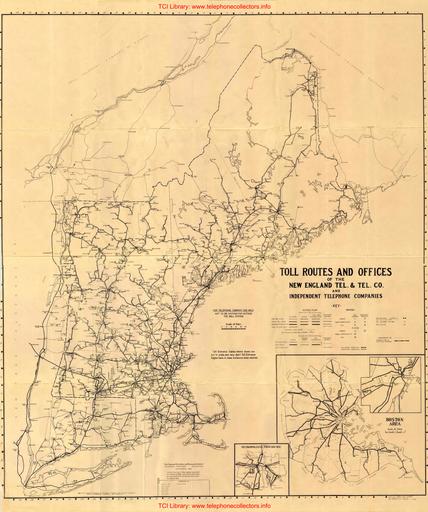
A rare New England Telephone & Telegraph Company Toll Route map covering MA, VT, ME, and RI including neighboring SNET (CT) territory. Also includes facilities of AT&T. Richly detailed including office type (Magneto / Manual Common Battery / Dial). A tremendous amount of information covering a large area. Includes vintage radio links to Block Island and Nantucket. Originally issued in Sep. 1942. Contributed by Rick Walsh.
New User?
Read the articles under "Introduction" in the black menu bar above.
Recent Contributors
Thanks for new documents from Lou Maffei, Rick Thoensen. Paul Fassbender, Sheila Flory, Tom Hesson, Jim Hurtle, Ed Palazzo, Bruce Patterson, Remco Enthoven, Jon Kolger, Paul Ivester, Len Hicken, Fred Haynes, Kurt Rudolph, Wade ("Kellogg KITT"), the Connections Museum, Rick Walsh, and Jeff Lamb.
Please send a file to add your name to this list!
30 Latest Additions
-
-
-
-
-
-
-
-
-
-
-
-
-
-
-
-
-
-
-
-
Beco 1011-DTP User Manual Popular
-
-
-
-
-
-
-
-
-
-
Who's online
We have 341 guests online
Hints for using the TCI Library
Three search options.
When browsing, to change the category listing view from normal to compact, click on Browse the Library in the black menu bar.